INDEX | PARTNER | DAFTAR/CARI | PART - 1 | PART - 2 | PART - 3
As per request from audience, herewith the English translation in italic located right below the Bahasa Indonesia version in each Paragraph.
Dalam artikel ini akan di sajikan info properti berupa tanah dengan luas 50 Hektar (50 x 10.000m = 500.000 m persegi) di daerah Serpong Tangerang. Foto dan video clip lengkap hasil liputan akan ditayangkan dalam 3 artikel. Setiap artikel akan bisa anda akses dengan mudah melalui link di atas.
In this article will present information on a property with a land area of 50 hectares (50 x 10,000 = 500,000 sq m) in Serpong Tangerang. Photos and video clips will be airing complete coverage of the results in the third article. Every article you will be able to easily access via the link above.

Gambar - 1 - Lokasi GPS
Lokasi GPS -6.41716402955353,106.646729009225
*Tips: Bagaimana cara memasukkan koordinat GPS?
Tanah ini lokasinya di selatan BSD - Bumi Serpong Damai, lokasi tanah ini sangat luas dan sangat-sangat potensial untuk dikembangkan menjadi sebuah kawasan pemukiman yang bernuansa alam.
This land is located in the south BSD - Bumi Serpong Damai, location land is very broad and very-very potential to be developed into a residential area of natural shades.
Keunikan lokasi ini adalah tanah yang berkontur berbukit dan terbelah oleh sungai yang dapat direkayasa menjadi tempat yang apik dengan desain yang menawan.
The uniqueness of this location is contoured land is mountainous and divided by a river that can be engineered into place nicely with charming designs.
INDEX | PARTNER | DAFTAR/CARI | PART - 1 | PART - 2 | PART - 3
Bagi anda yang berminat, atau ingin mendapatkan informasi tambahan silakan hubungi kontak kami di email, pin BB, serta SMS atau call nomor berikut:
For those of you who are interested, or would like to obtain additional information please contact us at the contact email, BB pin, as well as SMS or call the following numbers:
- Bandung:
Please write property code: 1052-1 when you contact us via SMS, call or email ##
# memudahkan tracking dan pencarian informasi properti
## Facilitate tracking and searching property information
Team propertidong, melakukan penelusuran dengan menangkap batas-batas tanah yang dimiliki secara jelas. Beberapa lokasi yang sulit dijangkau memang tidak diambil informasi detilnya, namun sebagian besar data dapat dilihat berikut ini.
Propertidong Team perform a search with the capture the land borders. Some locations are difficult to reach, some of the information captured is not detail, but most of the data can be reviewed as follows.
Foto Pelengkap & Video Clip
Pictures & Video Clips


Gambar - 2 - Portal dan Pintu masuk Tanah / Portal and Land entrance.
Clip - 1 - Video Batas tanah tempat masuk lokasi / Video land border at entry point.

Gambar - 3 - Helicopter View tanah secara total, titik-titik yang ada dalam gambar adalah lokasi yang dikunjungi saat survey dan didata informasinya. Akan ada istilah marker (titik) dengan nomor urut sesuai gambar. Misalnya Marker 15 artinya lokasi di ujung kiri atas yang dikunjungi dan merupakan batas tanah. Helicopter view di atas memiliki lokasi titik yang menumpuk satu sama lain karena keterbatasan layar, untuk alasan itu maka ditampilkan belahan potongan dalam gambar berikut ini untuk memudahkan navigasi, perhatikan Tips yang diberikan di bawahnya.
Helicopter View of land in total, the points in the pictures are the locations visited during survey. There will be a term marker (dot) with the number match the image. Marker 15 means the location at the top left corner and visited a land boundary for ease of navigation, consider the tips given below.

Gambar - 4 - Helicopter View untuk Sisi kiri Sungai. foto ini akan di tayang ulang bila dirasakan perlu di Part Berikutnya - lihat tips setelah gambar 5 di bawah/ Helicopter View to the left side of the river. These photos will be in reruns when deemed necessary in the Next Part - see tips after figure 5 below.

Gambar - 5 - Helicopter View untuk sisi kanan sungai, foto ini akan di tayang ulang bila dirasakan perlu di Part Berikutnya/ Helicopter View to the right side of the river, this photo will be in reruns when it is felt necessary in Part Next.
Tips: Untuk memudahkan navigasi, silakan anda buka gambar 4 dan 5 di atas di window yang berbeda dalam browser anda, sehingga memudahkan pindah layar saat anda hendak melihat dan mencocokkan lokasi. Gunakan Alt+Tab jika anda menggunakan operating system Windows dan Command+Tab untuk anda yang menggunakan MAC OS.
For easier navigation, please open images 4 and 5 above in a different window in your browser, making it easier to move the screen when you want to see and match the location. Use Alt + Tab if you use the operating system Windows and Command + Tab for MAC OS you are using.


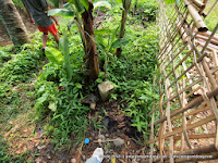
Gambar - 6 - Foto dari marker 1 dan sekitarnya, apabila anda ingin melihat foto di atas secara lebih jelas, bisa klik foto yang dimaksud/ Photos from marker 1 and the surrounding areas, if you want to see photo above more clearly, can click the photo in question.


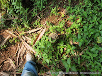
Gambar - 7 - Pemandangan dari marker 3, 4, 5, dan 6/ View from marker 3, 4, 5, and 6
Clip - 2 - Pemandangan di marker 5 / Landscape at marker 5


Gambar - 8 - Pemandangan dari marker 8 dan 9 (lapangan bola tidak permanen) / View from marker 8 and 9 (a football field is not permanent)
Clip - 3 - Pemandangan sungai / River view
Clip - 4 - Pemandangan di marker 8 / View in marker 8

Gambar - 9 - Foto atas marker 10, foto bawah marker 11, ada batas tanah yang jelas berupa tanda beton cor / Photos on marker 10, bottom photo marker 11, there is a clear boundary in the form of cast concrete sign.


Gambar - 10 - Foto di marker 12, 13, dan 14 lihat gambar 4 di atas untuk keterangan lokasi marker yang disebutkan / Pictures at marker 12, 13, and 14, see Figure 4 above for a description of where the marker is mentioned
Clip - 5 - Video Clip marker 14


Gambar - 11 - Foto di marker 15 ini adalah batas tanah penting untuk melihat batas atas tanah di gambar 4. Batu adalah batas tanah di marker 15 / Pictures at marker 15, this is important to look at the land boundary land boundary in figure 4. Stone is in the boundary marker 15.
Clip - 6 - Video clip di marker 15 - batas tanah / Video clip on marker 15 - boundary


Gambar - 12 - Berbalik dari marker 15, berbalik mendaki daerah tebing yang merupakan batas tanah di sisi luar. Marker 16 dan 17/ back from marker 15, turned up the cliff that borders the area on the ground outside. Marker 16 and 17.
Catatan: Marker 18 dan 19 tidak ditayangkan karena hanya numpang lewat lokasi jalan milik desa, Marker 18 and 19 are not shown because just ride through the village-owned path.
Clip - 7 - Video Clip sekeliling marker 15 & 16/ Video Clip serounding marker 15 & 16
Clip - 8 - Video Clip marker 17


Gambar - 13 - Marker 20, adalah batas tanah berikutnya. Kedua foto ini diambil di marker 20. Foto ketiga adalah marker 22/ Marker 20, is the next boundary. The second photo was taken at marker 20. The third photo is a marker 22.
Clip - 9 - Marker 20 dan pemandangan sekitarnya / Marker 20 and the surrounding landscape
Clip - 10 - Marker 22 Batas tanah kiri dan kanan / Marker 22 left and right limit of land


Gambar - 14 - Batas tanah beton di marker 23, pohon di marker 24, dan 25, masing-masing satu foto/ Limits on the concrete ground marker 23, tree marker 24, and 25, one photo each.
Clip - 11 - Marker 25 Batas tanah/ 25 Boundary Marker ground


Gambar - 15 - Marker 26 - batas beton foto pertama, Marker 27 dua foto selanjutnya/ Marker 26 - concrete boundary first photo, Marker 27, the next two photos.


Gambar - 16 - Marker 28 - batas beton, Marker 29 ditandai pohon (foto kedua)/ Marker 28 - concrete boundary, Marker 29 marked trees (second photo)
Clip - 12 - Batas marker 29 / Boundary marker 29


Gambar - 17 - Marker 30 - foto tempat orang berdiri, posisi di tebing. Dilanjutkan dengan posisi Marker 31/ Marker 30 - photos where people stand, position on the cliffs. Followed by the position of Marker 31.
Clip - 13 - Batas tebing di marker 30, tepatnya di posisi orang berdiri/ The Limit on a cliff at marker 30, to be exact in the man standing position
INDEX | PARTNER | DAFTAR/CARI | PART - 1 | PART - 2 | PART - 3
Bersambung ke Part - 2 / Continued to Part - 2
Apabila anda menggunakan QR Scanner, silakan scan kode berikut untuk mengakses halaman INDEX dengan cepat.
Should you use a QR scanner, please scan the following code to access the INDEX page quickly

"Cari Properti? Cek Properti Dong"
email: info@propertidong.com
http://www.propertidong.id
follow us on twitter: @propertidong
INDEX | PARTNER | DAFTAR/CARI | PART - 1 | PART - 2 | PART - 3
As per request from audience, herewith the English translation in italic located right below the Bahasa Indonesia version in each Paragraph.
Dalam artikel ini akan di sajikan info properti berupa tanah dengan luas 50 Hektar (50 x 10.000m = 500.000 m persegi) di daerah Serpong Tangerang. Foto dan video clip lengkap hasil liputan akan ditayangkan dalam 3 artikel. Setiap artikel akan bisa anda akses dengan mudah melalui link di atas.
In this article will present information on a property with a land area of 50 hectares (50 x 10,000 = 500,000 sq m) in Serpong Tangerang. Photos and video clips will be airing complete coverage of the results in the third article. Every article you will be able to easily access via the link above.
Gambar - 1 - Lokasi GPS
Lokasi GPS -6.41716402955353,106.646729009225
*Tips: Bagaimana cara memasukkan koordinat GPS?
Tanah ini lokasinya di selatan BSD - Bumi Serpong Damai, lokasi tanah ini sangat luas dan sangat-sangat potensial untuk dikembangkan menjadi sebuah kawasan pemukiman yang bernuansa alam.
This land is located in the south BSD - Bumi Serpong Damai, location land is very broad and very-very potential to be developed into a residential area of natural shades.
Keunikan lokasi ini adalah tanah yang berkontur berbukit dan terbelah oleh sungai yang dapat direkayasa menjadi tempat yang apik dengan desain yang menawan.
The uniqueness of this location is contoured land is mountainous and divided by a river that can be engineered into place nicely with charming designs.
Spesifikasi umum / General Spesification:
- Luas tanah +/- 50 hektar/ The land area of +/- 50 acres
- Status kepemilikan tanah atas nama perorangan/ Ownership status of the land on behalf of individuals
- Seluruh tanah telah memiliki SHM/ All lands has Ownership Certificate.
- Jalan akses sudah dimiliki, namun saat ini belum dibangun - lebar jalan akses 8 (delapan) meter/ Access road is owned, but not currently built - access road width 8 (eight) meters.
- Akses jalan tol sudah dalam rencana JORR tahap 3 di km Toll km 7 (Tirtawarna) sedang dibangun BSD, lalu km 8, 9, dan 10 melintas mendekati lokasi, berjarak 1 km dari toll / Access toll roads already planned for stage-3 JORR; marks on km 7 (Tirtawarna) is being built by BSD, kilometers 8, 9, and 10 pass close to the location, within 1 km from toll.
INDEX | PARTNER | DAFTAR/CARI | PART - 1 | PART - 2 | PART - 3
Bagi anda yang berminat, atau ingin mendapatkan informasi tambahan silakan hubungi kontak kami di email, pin BB, serta SMS atau call nomor berikut:
For those of you who are interested, or would like to obtain additional information please contact us at the contact email, BB pin, as well as SMS or call the following numbers:
- Bandung:
- Devy - devy.kristanto@propertidong.com; HP:022-76344646; Pin:759F58E3
- Kiki - kiki.wibowo@propertidong.com; HP/ Whatsapp:0811-908730; Pin:76538F72
- Kiki - kiki.wibowo@propertidong.com; HP/ Whatsapp:0811-908730; Pin:76538F72
- Adrian - adrian.qamar@propertidong.com; HP:081280456000
- Abraham Tirtawarna - donnyabraham57@gmail.com; HP:081219915669; Pin: 22010F03
Please write property code: 1052-1 when you contact us via SMS, call or email ##
# memudahkan tracking dan pencarian informasi properti
## Facilitate tracking and searching property information
Team propertidong, melakukan penelusuran dengan menangkap batas-batas tanah yang dimiliki secara jelas. Beberapa lokasi yang sulit dijangkau memang tidak diambil informasi detilnya, namun sebagian besar data dapat dilihat berikut ini.
Propertidong Team perform a search with the capture the land borders. Some locations are difficult to reach, some of the information captured is not detail, but most of the data can be reviewed as follows.
Foto Pelengkap & Video Clip
Pictures & Video Clips
Dari hasil survey kami, beberapa foto pelengkap yang dapat disajikan adalah sbb:
From the results of our survey, some supplementary photos can be presented as follows:
From the results of our survey, some supplementary photos can be presented as follows:


Gambar - 3 - Helicopter View tanah secara total, titik-titik yang ada dalam gambar adalah lokasi yang dikunjungi saat survey dan didata informasinya. Akan ada istilah marker (titik) dengan nomor urut sesuai gambar. Misalnya Marker 15 artinya lokasi di ujung kiri atas yang dikunjungi dan merupakan batas tanah. Helicopter view di atas memiliki lokasi titik yang menumpuk satu sama lain karena keterbatasan layar, untuk alasan itu maka ditampilkan belahan potongan dalam gambar berikut ini untuk memudahkan navigasi, perhatikan Tips yang diberikan di bawahnya.
Helicopter View of land in total, the points in the pictures are the locations visited during survey. There will be a term marker (dot) with the number match the image. Marker 15 means the location at the top left corner and visited a land boundary for ease of navigation, consider the tips given below.


For easier navigation, please open images 4 and 5 above in a different window in your browser, making it easier to move the screen when you want to see and match the location. Use Alt + Tab if you use the operating system Windows and Command + Tab for MAC OS you are using.


Clip - 2 - Pemandangan di marker 5 / Landscape at marker 5


Clip - 3 - Pemandangan sungai / River view
Clip - 4 - Pemandangan di marker 8 / View in marker 8


Clip - 6 - Video clip di marker 15 - batas tanah / Video clip on marker 15 - boundary


Catatan: Marker 18 dan 19 tidak ditayangkan karena hanya numpang lewat lokasi jalan milik desa, Marker 18 and 19 are not shown because just ride through the village-owned path.
Clip - 8 - Video Clip marker 17


Clip - 10 - Marker 22 Batas tanah kiri dan kanan / Marker 22 left and right limit of land


Clip - 12 - Batas marker 29 / Boundary marker 29


Clip - 13 - Batas tebing di marker 30, tepatnya di posisi orang berdiri/ The Limit on a cliff at marker 30, to be exact in the man standing position
INDEX | PARTNER | DAFTAR/CARI | PART - 1 | PART - 2 | PART - 3
Bersambung ke Part - 2 / Continued to Part - 2
Should you use a QR scanner, please scan the following code to access the INDEX page quickly

email: info@propertidong.com
http://www.propertidong.id
follow us on twitter: @propertidong
INDEX | PARTNER | DAFTAR/CARI | PART - 1 | PART - 2 | PART - 3
Tidak ada komentar:
Posting Komentar
Silakan kontak kami di alamat email: propertidong@gmail.com atau SMS atau whatsapp kami, harga akan kami beritahukan pada anda yang kontak dan meninggalkan informasi kontak yang jelas *menunjukkan keseriusan - thanks*